


Aswan High Dam — Complete Visitor Guide 2026
For seven thousand years, the annual Nile flood defined Egyptian life. Each summer, the river rose, spread across the floodplain, deposited a layer of rich black silt and receded — leaving behind the soil in which Egypt’s crops grew. The flood was unpredictable: too low and the harvest failed; too high and villages were destroyed. The entire calendar, the tax system, the religious cycle and the agricultural economy of ancient Egypt revolved around this annual event. In 1971, the Aswan High Dam ended it. The flood that had shaped Egyptian civilisation since before the pharaohs was stopped, captured and controlled by 43 million cubic metres of rock-fill and concrete across the Nile gorge south of Aswan. What replaced it — year-round irrigation, hydroelectric power, controlled water release, and a 550-kilometre artificial lake extending into Sudan — transformed Egypt into a modern state. What was lost — the annual silt, the Nubian homeland, dozens of ancient temples — is the other half of the story. Both halves belong to any honest understanding of the dam. This guide is written by Ahmed Emam with 15 years of visiting the dam with international clients.
The Dam in Numbers
The Political Story — Nasser, Suez and the Soviet Union
The history of the Aswan High Dam cannot be separated from the most dramatic geopolitical crisis of 1950s Egypt. President Gamal Abdel Nasser had been negotiating with the United States and Britain to fund the dam since 1952. In July 1956, US Secretary of State John Foster Dulles abruptly withdrew the American funding offer, citing Egypt’s arms deal with Czechoslovakia (a Soviet bloc country). Nasser’s response was immediate and radical: on 26 July 1956 — the fourth anniversary of King Farouk’s abdication — he announced before a huge crowd in Alexandria the nationalisation of the Suez Canal Company, seizing the canal’s revenues to fund the dam himself. Britain, France and Israel invaded Egypt in October 1956 in what became the Suez Crisis — one of the defining international events of the 20th century. Under pressure from both the United States and the Soviet Union, the invaders withdrew. Nasser emerged from the crisis as a pan-Arab hero across the Middle East. The Soviet Union stepped in where the West had withdrawn, providing technical expertise, equipment and US $1.12 billion in financing for the dam. Construction began in 1960 with approximately 34,000 Egyptian workers and 2,000 Soviet engineers. The Soviet-Egyptian friendship monument at the dam site — a stylised lotus flower — commemorates this partnership.
Benefits and Consequences — The Full Picture
The Nubian Displacement — The Human Cost
The most painful consequence of the High Dam was the forced relocation of approximately 100,000 Nubian people — Egyptian and Sudanese — whose villages, farmland, sacred sites and ancestral cemeteries lay in the path of the rising waters of Lake Nasser. Between 1963 and 1966, the Nubian communities of Lower Nubia were relocated to purpose-built villages in northern Aswan (Egyptian Nubians) and to Kashm el-Girba in eastern Sudan (Sudanese Nubians). The resettlement was poorly planned and inadequately resourced. The new villages did not replicate the Nile-side agricultural life the Nubians had maintained for millennia. Many Nubian families describe the displacement as a collective trauma that has not healed in three generations. Nubian culture survives actively in the villages around Aswan — the brightly coloured houses, the distinctive music, the crocodile-keeping tradition, the language — and the Nubian community on Elephantine Island and the villages north of Aswan offers visitors one of the most genuine cultural experiences available in Egypt. Awareness of the displacement adds an important dimension to the visit to the dam itself.
What to See at the Aswan High Dam
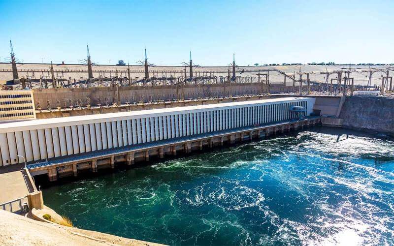
The dam is visited from a road that crosses its crest, giving a view of both the upstream face toward Lake Nasser and the downstream gorge with the Nile below. Key things to observe:
- The dam crest road — walking or driving across gives a sense of the scale: 3.8km from one bank to the other, with the blue expanse of Lake Nasser stretching south and the narrower Nile gorge visible to the north
- The Soviet-Egyptian Friendship Monument — a stylised lotus flower rising at the eastern end of the dam, built jointly by the Soviet and Egyptian governments to commemorate the partnership that built it
- The hydroelectric plant — the turbine hall at the northern (downstream) end houses the 12 turbines that generate Egypt’s hydroelectric power, visible from the dam road
- The view of Lake Nasser — the full extent of the reservoir is invisible from the dam (too vast), but the first stretch of the lake — calm, blue, vast — gives a visceral sense of what 157 billion cubic metres of stored water looks like
Practical Information
Ahmed Emam’s Insider Tips
- Ask your guide to tell the Suez Crisis story at the dam — the dam is not just an engineering structure. Standing on its crest, understanding the chain of events from Dulles withdrawing US funding to Nasser nationalising the canal to the Soviet engineers building what you are standing on, turns a concrete structure into one of the defining stories of 20th-century geopolitics.
- Look at both sides of the dam simultaneously — from the crest, walk to the downstream railing first (Nile gorge below, turbines, narrower river) then to the upstream face (Lake Nasser, vast and blue, silence). The contrast between the controlled Nile downstream and the stored weight of a 550-kilometre lake upstream makes the engineering achievement immediately visceral.
- The Soviet-Egyptian monument rewards a close look — the lotus flower monument at the eastern end is rarely visited by tour groups who stop briefly on the dam road. Walk to it. The joint inscription in Arabic and Russian, and the knowledge that 2,000 Soviet engineers worked here alongside 34,000 Egyptian workers in the Cold War era, is historically affecting.
- Visit a Nubian village after the dam — the most meaningful way to contextualise the dam is to spend time in a Nubian community. The brightly painted houses, the distinctive culture and the community’s living memory of displacement are more powerful than anything that can be explained at the dam itself.
Frequently Asked Questions
Why was the Aswan High Dam built?
The Aswan High Dam was built for three primary reasons. First, to control the annual Nile flood — which was unpredictable, sometimes catastrophically high and sometimes too low to support agriculture. Second, to provide year-round irrigation water for Egyptian agriculture, enabling multiple crops per year and expanding cultivated land. Third, to generate hydroelectric power for Egypt’s rapidly growing population and industrialisation programme. The political context was also significant: President Nasser used the dam as a symbol of Egyptian national development and modernisation, and its construction — after the US withdrew funding — became intertwined with the Suez Crisis and Cold War politics.
What is the difference between the Aswan High Dam and the Aswan Low Dam?
There are two dams at Aswan. The Aswan Low Dam (also called the Old Dam) was built by the British and completed in 1902, heightened in 1912 and again in 1933. It is 8km north of the High Dam, and its spillway was designed to allow some floodwater through. The Low Dam was not sufficient to control the flood fully or to create a major reservoir. The Aswan High Dam (Sadd el-Aali) was completed in 1971, 13km south of the Low Dam. It is dramatically larger — 111 metres high versus 54 metres — and fully controls the Nile, creating Lake Nasser. Both dams are visible in the Aswan area; the Nile cruise route passes through the locks of the Old Dam.
What happened to the Nubian people when the dam was built?
Approximately 100,000 Nubian people were forcibly displaced from their villages in Lower Nubia between 1963 and 1966 as Lake Nasser rose. Egyptian Nubians were relocated to purpose-built villages in Kom Ombo and the Aswan area; Sudanese Nubians were relocated to Kashm el-Girba in eastern Sudan. The relocations were carried out with insufficient planning and compensation. The submerged villages, farmland and ancestral cemeteries represent an irreplaceable cultural loss. Nubian culture remains alive in the Aswan region and is actively maintained by the community, but the displacement is widely described as a generational trauma that has not fully healed.
How big is Lake Nasser?
Lake Nasser is one of the world’s largest artificial lakes. It stretches 550km from the High Dam at Aswan southward into Sudan, where it is called Lake Nubia. Its maximum width is approximately 35km and its maximum depth is 130 metres. It stores 157 billion cubic metres of water. The lake is the foundation of Egypt’s water security and is also navigated by Lake Nasser cruises that sail between Aswan and Abu Simbel, stopping at Nubian temples only accessible by water.
How did the Aswan High Dam trigger the Suez Crisis?
The causal sequence: In July 1956, the US withdrew its offer to fund the dam, citing Egypt’s arms purchase from Czechoslovakia. Nasser responded by nationalising the Suez Canal on 26 July 1956, declaring that canal revenues would fund the dam instead. Britain and France, who owned the canal company, coordinated with Israel to invade Egypt in October 1956 (the Suez Crisis). Under US and Soviet pressure, the invasion was reversed. Nasser emerged strengthened; the Soviet Union stepped in to fund and build the dam. The dam is therefore both the cause and the consequence of the Suez Crisis — the most significant event in modern Egyptian political history.
The dam is included in all our Nile cruise Aswan itineraries and Cairo and Nile cruise packages from $899 — combined with Philae Temple and the Unfinished Obelisk. Contact us for a free personalised Aswan itinerary.
Written by Ahmed Emam — Egypt travel specialist since 2010, founder of Around Egypt Tours. Has visited the Aswan High Dam with international clients on over 400 occasions.